USGS MAUNA LOA AFTERNOON UPDATE FOR DAY 7

2:45 AM · Dec 5, 2022

USGS (4:22pm) - The Northeast Rift Zone eruption of Mauna Loa continues. One active fissure, fissure 3, is feeding a lava flow downslope. Fissure 3 is generating a lava flow traveling to the north toward the Daniel K. Inouye Highway (Saddle Road) that has reached relatively flatter ground and slowed down significantly over the past several days, as expected. As of 12 p.m. today, December 4, the flow front was about 2.25 mi (3.6 km) from the Daniel K. Inouye Highway (Saddle Road). Where the fissure 3 lava channel is branching, on the steeper slopes of the Northeast flank about half way down the lava flow, there were several small overflows recorded over the past day. During the past 24 hours, the lava flow advanced at an average rate of about 40 feet per hour (12 meters per hour). Though the advance rate has slowed over the past several days, the lava flow remains active with a continuous supply from the fissure 3 vent. Advance rates may be highly variable over the coming days and weeks. On the flat ground between Mauna Loa and Mauna Kea, lava flows advance more slowly, spread out, and inflate. Individual lobes may advance quickly, and then stall. Additional breakouts may occur if lava channels get blocked upslope. There are many variables at play and both the direction and timing of flow advances are expected to change over periods of hours to days, making it difficult to estimate when or if the flow will impact Daniel K. Inouye Highway. Sulfur dioxide (SO2) emission rates of approximately 180,000 tonnes per day (t/d) were measured on December 1, 2022 and remain elevated at this time. Volcanic gas is rising high and vertically into the atmosphere before being blown to the west at high altitude, generating vog (volcanic air pollution) in areas downwind. The International Volcanic Health Hazard Network has detailed information about vog: https://vog.ivhhn.org/. Forecasts for the dispersion of vog can be found on the Mauna Loa Vog Forecasting Dashboard: https://vog.ivhhn.org/content/mauna-loa-eruption. Tremor (a signal associated with subsurface fluid movement) continues beneath the currently active fissures. This indicates that magma is still being supplied to the fissure, and activity is likely to continue as long as we see this signal. There is no active lava within Moku'āweoweo caldera nor the Southwest Rift Zone. We do not expect any eruptive activity outside the Northeast Rift Zone. ---- Video is a timelapse of Fissure 3 on Mauna Loa and it's lava flow heading towards Saddle road overnight.
Subscribe to newsletter

Receive the latest updates from Hawaii Tracker to your inbox!

Paused Eruption at Kilauea Volcano Has Reactivated

Paused Eruption at Kilauea Volcano Has Reactivated

The eruption of Kīlauea volcano that paused through the night, reactivated at several of the vents along the southwest of Halema‘uma‘u crater floor. Eruptive activity remains confined to Halemaʻumaʻu and the downdropped block within the caldera and may fluctuate in vigor over the coming days. No unusual activity has been noted along Kīlauea’s East Rift Zone or Southwest Rift Zone. Seismicity at the summit over the past day has been low with about 8 earthquakes all below magnitude-2.0. At the onset of the eruption yesterday morning, Dec 23, seismic tremor was high. However, around 3 pm yesterday, seismic tremor began to decrease, and currently there is low to moderate tremor related to vent activity. After the summit eruption began, summit tilt meters recorded rapid to moderate deflation until late afternoon. Around 3 pm yesterday, Kīlauea’s summit began slowly inflating. Based on ground instruments, the SO2 emissions were estimated to be over 100,000 tonnes per day during the initial stages of the eruption and dropped to about half of that by mid-day yesterday before the pause. Fountaining decreased abruptly at 3:30 pm yesterday and had ceased by 4:00 pm. Drainback of lava into the original vents began soon after fountaining stopped and continued through the night. Drainback reversed around 8 am this morning, Dec 24, and low-level eruption of sluggish lava occurred from several of yesterday’s vents. Fountains began increasing in vigor around 11:00 am, signaling the onset of a second episode of this eruption. Breakouts of red lava are also visible on the surface of the lava lake as it continues to circulate. A data problem last night resulted in images from Halemaʻumaʻu crater being displayed on a Nāpau Crater camera site. There is no eruptive activity in Nāpau Crater, and the camera has been temporarily taken offline for maintenance. View the Kīlauea summit eruption livestream at: https://www.youtube.com/usgs/live

Ryan Finlay · 14d

New Eruption Has Paused

New Eruption Has Paused

The eruption in Halema'uma'u crater within Kaluapele (Kīlauea summit caldera) that began at 2:20 am HST this morning, December 23, appears to be paused. Throughout most of the day, lava fountained from vents in the southwest portion of the caldera. Initial fountain heights were estimated to be about 260 to 300 feet (80-90 meters) but decreased to about 55 yards (50 m) by 1:00 p.m. Around 3 pm, tilt at the summit stopped showing deflation and seismic tremor began decreasing. By 3:30 pm, lava fountains were barely visible. By 4 pm, fountaining stopped, and seismic tremor was close to background levels. Visible volcanic gas emissions also decreased significantly. The Kīlauea summit livestream video is available here: https://www.youtube.com/usgs/live Lava has covered approximately 650 acres, including all of Halema'uma'u and most of the adjacent downdropped block. The lava is estimated to be about 1 yard (1 meter) thick, giving an estimated average effusion rate of 110 cubic yards per second (85 cubic meters per second) for the first 8 hours of the eruption. Conditions prevented measuring sulfur dioxide (SO2) gas emission rates by normal methods, but nearby monitoring stations estimated over 100,000 tonnes of SO2 per day around 8:00 am and decreasing by half in the early afternoon. These estimates are similar to values measured in the early stages of previous summit eruptions in the past 4 years. HVO continues to closely monitor Kīlauea and will issue an eruption update tomorrow morning unless there are significant changes overnight. USGS photos: A lobe of molten pāhoehoe lava on the floor of Kaluapele (Kīlauea caldera) on December 23, 2024 (photo by M. Patrick). Aerial view from the morning overflight shows the crater floor paved with new rock (photo by M. Zoeller). More Kīlauea photos/video: https://www.usgs.gov/volcanoes/kilauea/photo-and-video-chronology HAWAIIAN VOLCANO OBSERVATORY STATUS REPORT U.S. Geological Survey Monday, December 23, 2024, 5:14 PM HST KILAUEA (VNUM #332010) 19°25'16" N 155°17'13" W, Summit Elevation 4091 ft (1247 m) Current Volcano Alert Level: WATCH Current Aviation Color Code: ORANGE Activity Summary: The eruption of Kīlauea slowed significantly between 3:00 and 4:00 p.m. and appears to be paused. The eruption in Halema'uma'u crater within Kaluapele (Kīlauea summit caldera) that began at 2:20 a.m. HST this morning, December 23, continued through most of the day within a closed area of Hawaiʻi Volcanoes National Park. There was no immediate threat to human life or infrastructure, but emission rates of volcanic gases were very high. Webcam imagery and field crew observations showed continued lava fountaining from vents in the southwest portion of the caldera with new lava covering approximately 650 acres, including all of Halema'uma'u and most of the adjacent downdropped block. The area covered so far is a little more than 1 square mile (2.6 square kilometers) and represents about one quarter of the area of Kaluapele. The lava is estimated to be about 1 yard (1 meter) thick, giving an estimated average effusion rate of 110 cubic yards per second (85 cubic meters per second) for the first 8 hours of the eruption. Initial fountain heights were estimated to be about 260 to 300 feet (80-90 meters) and had decreased to about 55 yards (50 m) by 1:00 p.m. Vigorous fountaining produced a plume of volcanic gas and particles that was transported downwind, in a southwest direction over a closed area of Hawaiʻi Volcanoes National Park. Conditions prevented measuring SO2 gas emission rates by normal methods, but nearby monitoring stations estimated over 100,000 tonnes of SO2 per day around 8:00 a.m.and decreasing by half in the early afternoon. These estimates are similar to values measured in the early stages of previous summit eruptions in the past 4 years. Around 3 p.m. today, tilt at the summit stopped showing deflation and seismic tremor began decreasing. By 3:30 p.m., lava fountains were barely visible. By 4 p.m., fountaining had stopped and seismic tremor was close to background levels. Visible volcanic gas emissions have also decreased significantly. These observations indicate that the eruption has slowed significantly and appears to be entering a pause. HVO continues to closely monitor Kīlauea and will issue an eruption update tomorrow morning unless there are significant changes overnight. HVO remains in close contact with Hawai‘i Volcanoes National Park and the Hawai‘i County Civil Defense Agency. Please see the Hawaiʻi Volcanoes National Park website for visitor information: https://www.nps.gov/havo/index.htm The Kīlauea summit livestream video is available here: https://www.youtube.com/usgs/live

Ryan Finlay · 14d

New Eruption Begins Inside Halemaʻumaʻu Crater at Hawaiʻi Volcanoes National Park

New Eruption Begins Inside Halemaʻumaʻu Crater at Hawaiʻi Volcanoes National Park

A new eruption at the summit of Kīlauea volcano is drawing thousands of visitors to Hawaiʻi Volcanoes National Park eager to see new erupting lava by day and the lava glow after dark. This new eruption is viewable from almost all open areas around the caldera. While the park remains open 24 hours a day, some areas may close to protect breeding and nesting nēnē. While an eruption is an exciting experience, keep in mind you are observing a sacred event. The summit of Kīlauea volcano is a wahi kapu (sacred landscape) surrounded with storied places and a delicate ecosystem. The public is reminded to stay safe and help protect park resources by following these precautions: 🌋 Volcanic eruptions can be hazardous and change at any time. Stay on marked trails and overlooks and avoid earth cracks and cliff edges. 🚫 Do not enter closed areas. 💨 Hazardous volcanic gases are billowing out the crater and present a danger to everyone, especially people with heart or respiratory problems, infants, young children and pregnant women. Check the park air alert web page before and during your visit. 🚩 Slow down and drive safely. Expect long waits for parking spaces at popular vantage points like Uēkahuna (formerly the Jaggar Museum) and Devastation Trail parking area. 🐣 Do your part to help protect nēnē by keeping your distance, at least four car lengths away, and never feed nēnē or wildlife. Handouts make nēnē seek out people and cars, putting them in great danger. 🥶 At 4,000 feet, the summit of Kīlauea can be chilly at any time. Bring a rain jacket, wear long pants and closed-toe shoes. Bring a flashlight if visiting at night. So what can visitors expect to see? It depends on when they arrive, and the weather. In the Dark. A magnificent reddish orange glow fills the dark sky. Lava flows have covered much of Halemaʻumaʻu crater floor. The best eruption viewpoints day or night are along Crater Rim Trail, and include Uēkahuna, Kīlauea Overlook, Wahinekapu (Steaming Bluff), Kūpinaʻi Pali (Waldron Ledge), behind Volcano House, Keanakākoʻi and other overlooks. https://www.nps.gov/havo/planyourvisit/eruption-viewing-caldera.htm Image of bright orange lava fountains inside a dark crater at night. NPS photo/Janice Wei

Ryan Finlay · 15d

Hawaii's Pohoiki Boat Ramp Dredging Project in Puna Receives Green Light

Hawaii's Pohoiki Boat Ramp Dredging Project in Puna Receives Green Light

PUNA, HAWAII - After over 6 1/2 years of being closed, final approval for the dredging of the Pohoiki boat ramp has been made. The Hawaii Division of Boating and Ocean Recreation has awarded a dredging contract to Goodfellow Bros. LLC for the restoration of the Pohoiki Boat Ramp facility. The project aims to restore function to the boat ramp, which was severely impacted by the 2018 Kilauea Volcanic Eruption and Earthquakes disaster. During this event, Pohoiki Bay was inundated with volcanic sand, cobble, and boulders, leaving the existing boat ramp landlocked. The restoration project involves creating a channel through the volcanic debris to reconnect the boat ramp to the Pacific Ocean. Approximately 42,000 cubic yards of sediment will be removed through a combination of on-land excavation and mechanical dragline dredging. A portion of the dredged material will be repurposed to fill ponds created by volcanic debris accumulation in the bay's backshore area. The remaining material will be relocated to the main disposal site, which includes the lava land mass that covered the eastern end of the park and adjacent newly accreted land. Work is scheduled to begin in February 2025, with completion anticipated by November 2025, pending final permit approvals which are currently in process. For additional information about the project, interested parties can visit the official Hawaii Department of Land and Natural Resources website at: https://dlnr.hawaii.gov/dobor/fema-final-public-notice-for-pohoiki-boat-ramp-dredging-on-hawaii-island/ More information to come as it becomes available.

Ryan Finlay · 1 month ago

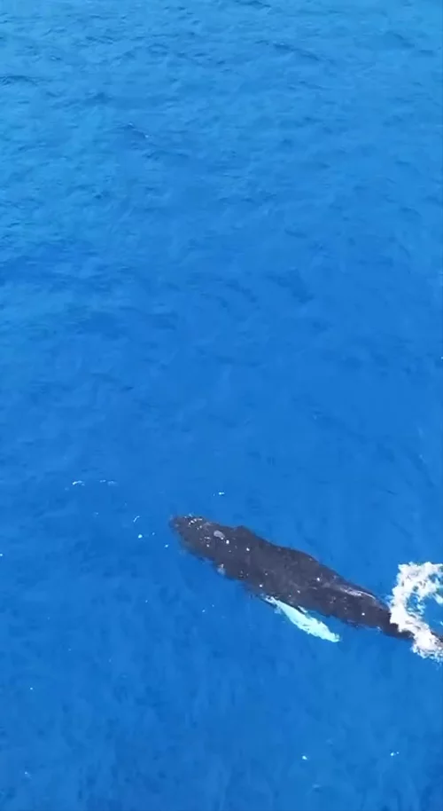
First Humpback Whale of the Season Spotted Off Kona Coast

First Humpback Whale of the Season Spotted Off Kona Coast

A Humpback Whale was spotted swimming off the coast of Kona today! Video by @sharksofhawaii on Instagram. It was the first humpback he’s spotted this season.

Ryan Finlay · 2 months ago

Supporting Our Friends at the Hawaiian Volcano Education and Resilience Institute (HVERI)

Supporting Our Friends at the Hawaiian Volcano Education and Resilience Institute (HVERI)

I have a favor to ask. Our friends Philip, Dane and Lou at the Hawaiian Volcano Education and Resilience Institute (HVERI) could use your support. As moderators of this group, they work throughout the year as your local, trusted source for the latest information on the island’s volcanic eruptions, disaster preparedness, community resilience and more. When things are quiet, they are working on helping keep the community informed and prepared for upcoming eruptions and other natural disasters. When those natural disasters arrive, they calmly respond with information you need and can trust without sensationalizing anything. Their goal is to be helpful to the community, and they have been doing an incredible job of it. They are supported partially by generous members of the Hawaii Tracker community, along with various grants they are able to get. If you have benefited from their work, please consider supporting them. Also, a big thank you to all of you who have helped support the work over the years! If you would like to help support the HVERI team, you can do so here: hveri.org/donate - Ryan

Ryan Finlay · 6 months ago